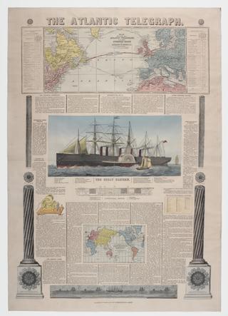
Broadsheet, printed, hand-coloured engravings, 'The Atlantic Telegraph', describing the laying of the first successful transatlantic telegraph cables, published by Bacon & Co, 48 Paternoster Row, London, England, 1866. The Atlantic Telegraph, broadsheet, 1866 1866
Bacon's map of Portsmouth, Portsea, Landport, Southsea and Gosport, showing the line of the proposed Southsea Railway, and rail and tram lines. Scale: 6"-1 mile. Bacon's map of Portsmouth post 1883
Map, Bacon's excelsior map of Lincolnshire and parts of adjoining counties showing railways, roads, elevations & distances; also local government divisions. c. 1906, coloured, 1 inch to 3 miles, publisher/printer G W Bacon & Co., paper-backed linen. Map, Bacon's excelsior map of Lincolnshire and parts of adjoining counties showing railways 1906
New Ordnance Atlas of the British Isles, with plans, enlarged environs of towns and an alphabetical index, London: George W Bacon, 1882, [loose sheets], outsize. Ordnance Atlas of the British Isles 1882
Map, Bacon's excelsior map of Yorkshire and parts of adjoining counties showing railways, roads, elevations & distances; also local government divisions. c. 1901, coloured, 1 inch to 3 miles, publisher/printer G W Bacon & Co., paper-backed linen. Map, Bacon's excelsior map of Yorkshire and parts of adjoining counties showing railways 1901
Map, card, "Map Of The New London Boroughs", manufactured by Bacon and Co, with advertisement on the inside cover for Charles Baker & Co, dimensions, 202 x 120mm. Bacon's Map of the New London Boroughs
Map, colliery map, 'Yorkshire, Derbyshire and Nottinghamshire Coalfield', c. 1909, coloured, printed by G W Bacon, paper-backed linen. Map, colliery map 1909
Map, cycling map, 'Yorkshire', c. 1885, 1 mile to 5 inches, coloured, publisher/printer G W Bacon & Co., paper. Map, cycling map 1885